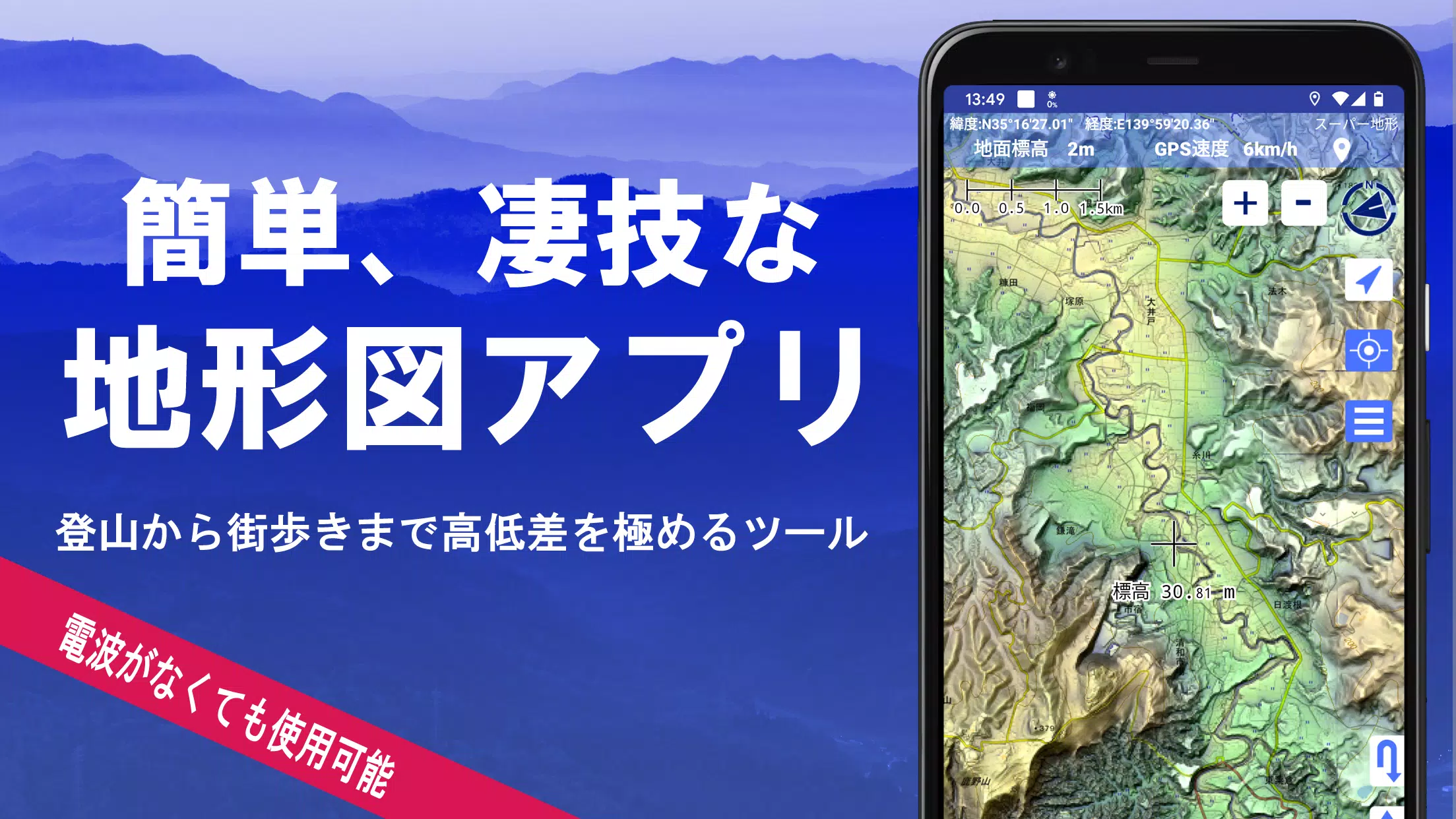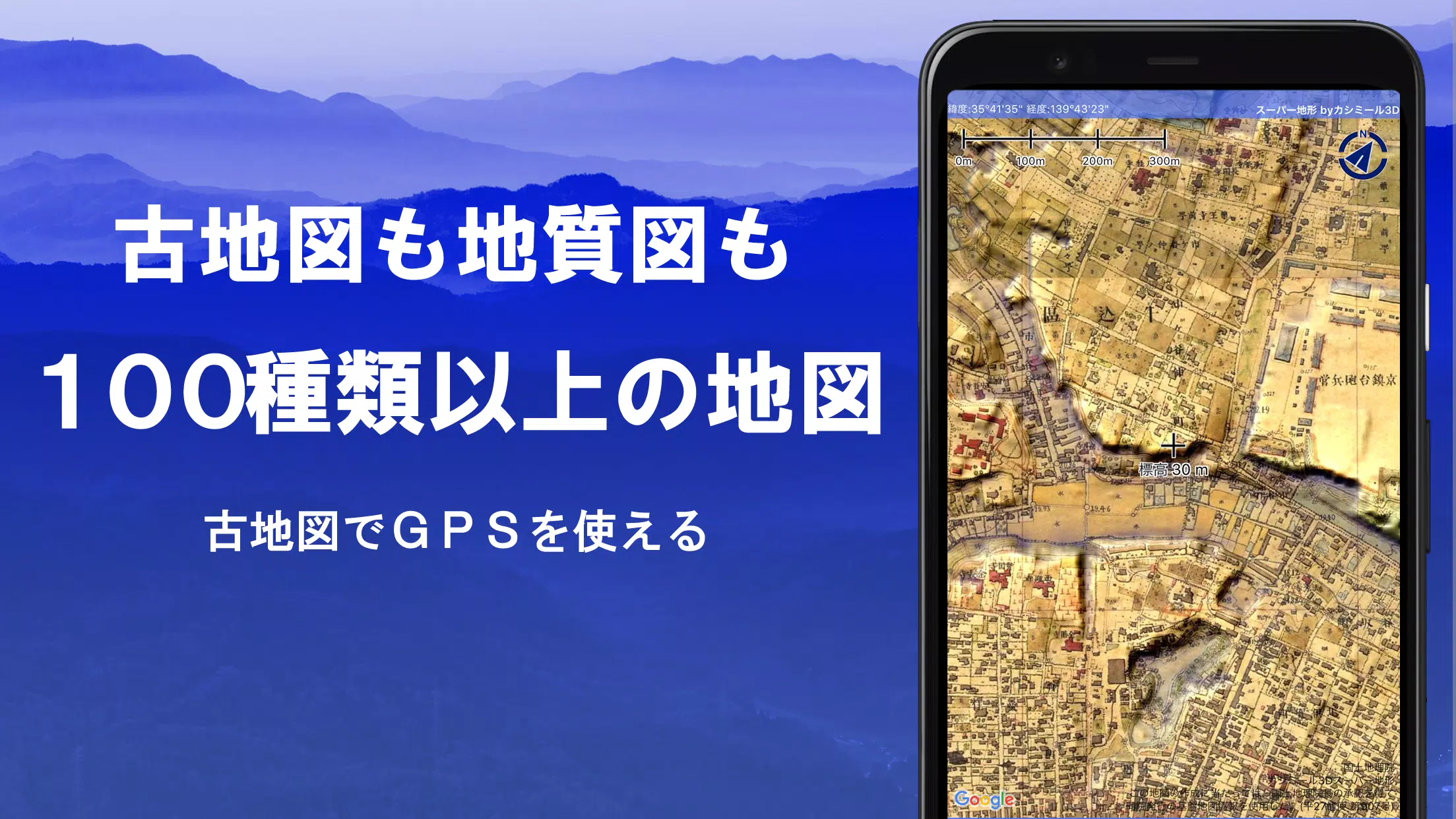
Explore over 100 types of maps, including those from the Geographical Survey Institute, to enhance your adventures from mountain climbing to urban strolls. These maps leverage the power of "super terrain data," a unique technology that emphasizes the terrain's features, giving you a detailed view of your surroundings.
In 2018, our commitment to excellence was recognized with the Japan Cartographic Society Award for Best Work, reflecting our dedication to providing the highest quality mapping solutions.
- Utilize "super terrain data" for a detailed terrain visualization.
- Access a variety of maps, including topographic, geological, and historical maps from the Geospatial Information Authority of Japan.
- Record your journeys with the GPS function, complete with GPX log input/output and editing capabilities.
- Benefit from features designed to support urban exploration, mountain climbing, and outdoor activities, such as GPS navigation with audio guidance and data management tools.
- Use the visibility determination function for creating cross-sectional diagrams, aiding in observation and radio communication, with the option to display buildings.
- Experience a 360° panoramic view function for mountain identification, and view celestial bodies like the sun and moon, along with GPS points.
- Enjoy offline map usage with bulk map downloads and a map cache function, ideal for remote areas without signal coverage.
- Associate photos with specific locations on the map.
- Visualize contour lines derived from elevation data.
- Display the MGRS grid (UTM grid) for precise navigation.
- Read, display, and edit GIS data from GeoJSON files.
- Draw custom shapes on the map.
- Use the app overseas for global adventures.
- Print maps or export them as PDFs.
- Switch to a dark theme for a comfortable viewing experience.
A Wealth of Maps at Your Fingertips
Our app offers over 100 types of maps, including our proprietary super topographic data and resources from the Geospatial Information Authority of Japan. Whether you're exploring aerial photographs from different eras or using the latest maps, you'll find comprehensive coverage to suit your needs. Note that some areas might lack photographs for certain time periods, but "Latest" and "around 1974" provide wide coverage. Enjoy a free 5-day trial of maps using super terrain data upon installing the app.
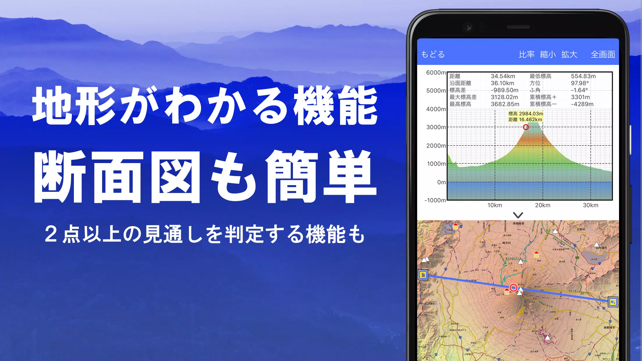
Creating Cross Sections and Outlooks
Effortlessly draw cross sections through any point on the map to better understand the terrain. Our visibility judgment function, a staple in Kashmir 3D, accounts for the Earth's curvature and atmospheric differences, aiding in route planning, wireless visibility assessments, and more. Where PLATEAU building data is available, include buildings in your cross-sectional views for added detail.
Elevation Palette Function
Customize your map's appearance with the elevation palette function, adjusting the background color in 1cm increments to create a visually pleasing gradation that matches your preferences.
Panoramic Views
Identify mountains effortlessly with our panoramic observation map, which displays mountain names from any location. The 360° panorama integrates with your smartphone's compass, perfect for mountain identification. You can also track celestial events like Diamond Fuji and Pearl Fuji, and view GPS point locations. Extend your panoramic views to mountains abroad.
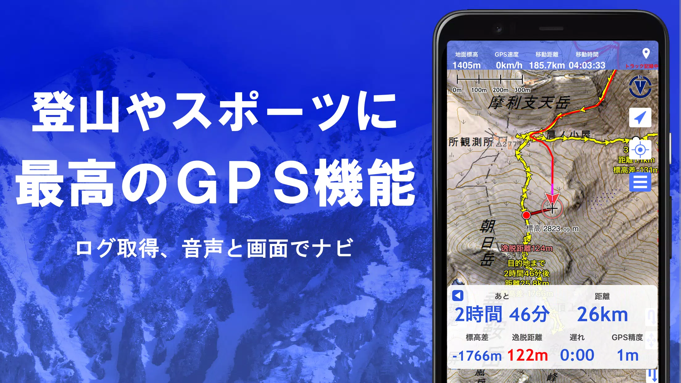
GPS Functionality
Leverage your smartphone's GPS to obtain precise location data and record your tracks. Our high-precision positioning is designed for rigorous mountain climbing and outdoor use. Visualize your recorded tracks with detailed parameters such as elevation change, speed, time, and elapsed time. The point alarm function alerts you with voice and sound as you approach designated points, and you can view photos associated with specific locations. Send the map center position to NaviCon for seamless navigation.
GPS Track Summary Playback
Replay your recorded tracks in full with our GPS track summary playback feature. It matches photos stored on your smartphone with the corresponding track times, displaying icons at photo locations for easy access.
GPS Navigation Function
Navigate along preset tracks using the Track Navi function, with voice or alarm notifications if you stray off course. This feature is invaluable for preventing disorientation during climbs. Additionally, enjoy route navigation for urban exploration and point navigation to reach specific locations.
GPS Data Editing Function
Manage GPS-related point, route, and track data with ease. Organize your data into folders displayed in a user-friendly tree format. Create tracks directly on the map and import or export data in GPX format from mountain climbing sites.
Map Usage Outside Service Areas (Offline)
Continue using maps in remote areas without signal coverage through our bulk download function, which allows you to download all scale maps for a specified area. The cache function ensures you always have the maps you need at your fingertips.
Map History Function
The app remembers your viewed locations, allowing you to easily return to previous points of interest.
Custom Map Compatibility
Import custom maps created with Kashmir 3D's map cutter, including your own maps and scanned images. When using the map cutter, divide images into approximately 256 x 256 segments and send the resulting kmz file to Super Terrain via email or Cloud Drive.
GeoJSON Compatibility
Display and edit points, linestrings, and polygons from GeoJSON format files, with the ability to draw new shapes directly on the map.
Print/PDF Output
Print any map area at a specified scale or generate a PDF for offline use.
Integration with Other Apps
Exchange GPS data in GPX, KML, and GDB formats with other apps and software, including Kashmir 3D on your PC, and utilize trajectory data from mountain climbing sites.
Backup Function
Back up all app data (excluding cached maps) and remove it from your smartphone. Restore your data even if you delete the app or experience a device malfunction. Utilize the automatic backup feature with Google Drive for up-to-date backups. Refer to the manual for detailed instructions.
Billing Function
Some features, such as maps using super terrain data, GPS track functions, and cross-sectional views, require in-app purchases. After payment, the number of search results for place name searches increases.
- Fees: Annual payment of 780 yen/year.
- Free Trial: Enjoy a 5-day free trial upon first installing the app. Some features and maps become unavailable after the trial period. No charges will be incurred unless you opt for a purchase.
- Purchase Process: To buy, navigate to [Settings] - [Purchase to remove functional restrictions] within the app.
- Confirmation and Cancellation: Check or cancel automatic updates via Google Play under "Regular Purchase" and select "Super Terrain."
- Price Revision: Prices may change with future enhancements. Early purchase is advantageous.
Terms of Use
The copyright holder and developer are not liable for the outcomes of using this application. Upon first use of GPS, allow the use of location information services. Note that continuous GPS use will drain your battery; if your device is crucial for emergency communication, carry a spare battery. For a detailed explanation of the navigation function, refer to the PDF at https://www.kashmir3d.com/online/superdemapp/superdem_navi.pdf. Be aware that some smartphones may interrupt or fail to record tracks due to power-saving features that close background apps. Turning off the screen while Super Terrain is displayed may temporarily maintain recording, but this is not a permanent solution.