The Japanese government has unveiled an immersive Minecraft map of the world’s largest underground flood prevention facility — the Metropolitan Area Outer Underground Discharge Channel, better known as G-Cans. This free-to-download experience allows players to explore one of Tokyo’s most visually striking and functionally impressive infrastructures without ever leaving home.
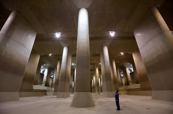
G-Cans is a marvel of modern engineering designed to protect the Greater Tokyo area from catastrophic flooding. It is perhaps best recognized by its awe-inspiring “pressure adjustment water tank” — a cathedral-like underground chamber supported by 59 colossal pillars. With its dramatic lighting and cavernous scale, this space has earned the nickname *chika shinden* (“underground temple”) in Japan. The location has even served as a backdrop for music videos, Japanese TV dramas like *Kamen Rider*, and films due to its unique visual appeal.
While physical tours of G-Cans are possible during dry seasons, the Japanese Ministry of Land, Infrastructure, Transport and Tourism (MLIT) now offers a virtual alternative through Minecraft. A dedicated YouTube video on the ministry's official channel provides a quick overview of G-Cans’ real-world purpose and showcases how it appears within the blocky environment of the game.
The G-Cans Minecraft map isn’t limited to just the underground structure. It also features a detailed overground area complete with rivers, houses, and local neighborhoods, helping players understand how the system safeguards populated regions from flooding. In-game, users can enter the control room and simulate the process of diverting excess rainwater into the massive underground shafts — offering a hands-on experience of how the system operates in reality.

This Minecraft recreation was developed as part of MLIT’s efforts to educate the public about disaster prevention and infrastructure resilience. Exploring G-Cans in-game gives players a strong sense of the sheer scale of the real facility. In actuality, G-Cans spans more than 6 kilometers beneath Saitama Prefecture, with five enormous vertical shafts collecting overflow from vulnerable rivers during Japan’s rainy season in June and typhoon season typically in September. The collected water is then gradually released into the Edogawa River and eventually into Tokyo Bay, significantly reducing the risk of urban flooding.
Construction of G-Cans took over a decade and was completed in 2006. Since then, it has played a crucial role in protecting millions of residents across the Tokyo metropolitan region from seasonal floods.
The G-Cans Minecraft map is available for free download via the official website of the Edogawa River Office, which oversees the facility. Compatible versions include Minecraft Bedrock Edition v1.21.1 or Minecraft Education Edition v1.21.0 and above.